1. The Celestial Theatre of the Canadian Sub-Arctic
Standing on the frozen surface of Great Slave Lake outside Yellowknife on a clear February midnight, the thermometer reads -35°C. The air is still, silent, and crystal clear. Suddenly, a faint curtain of emerald light ignites along the northern horizon. Within seconds, the ribbon broadens, surging across the zenith in violent waves of neon green, magenta, and violet.
The auroral curtains dance at velocities exceeding 50 kilometers per second, forming intricate coronal crowns that bathe the snow-covered boreal forest in eerie, ethereal illumination. This is the Aurora Borealis—the most spectacular optical manifestation of solar-terrestrial physics occurring in the upper atmosphere.
Northern Canada is recognized globally as the premier destination on Earth for observing the Northern Lights. Yellowknife, Whitehorse, Churchill, and Dawson City sit directly beneath the permanent statistical Auroral Oval, an annular belt centered on the geomagnetic pole where solar wind particles constantly rain down upon the ionosphere.
2. The Magnetospheric Engine: Solar Wind & Magnetic Reconnection
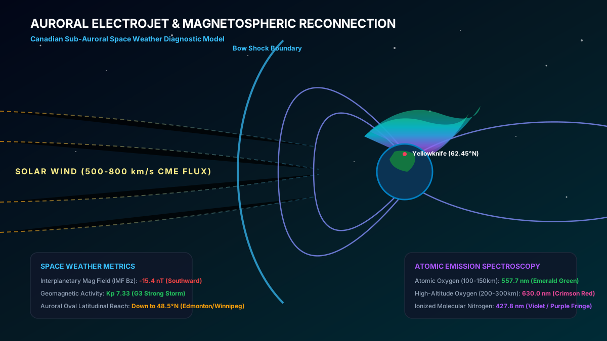
The Aurora Borealis is powered by the Sun’s continuous emission of magnetized plasma known as the Solar Wind. This stream of high-energy protons and electrons travels across interplanetary space at supersonic velocities ranging from 350 to over 800 km/s.
When this magnetized plasma strikes Earth’s geomagnetic shield (the Magnetosphere), it compresses the dayside magnetic field and stretches the nightside field into a vast cometary tail (the Magnetotail) extending hundreds of thousands of kilometers into space.
When the Interplanetary Magnetic Field (IMF) tilts southward (negative Bz orientation), magnetic reconnection occurs on the dayside, funneling solar wind energy into the magnetotail. When the stressed magnetic field lines snap back in a process known as Explosive Magnetic Reconnection, trillions of trapped electrons are accelerated downward along magnetic field lines directly into the upper atmosphere above Canada’s high latitudes.
3. Atmospheric Atomic Spectroscopy: Why the Lights Are Green and Violet
When accelerated electrons collide with atmospheric gas molecules at altitudes between 80 and 400 kilometers, they transfer kinetic energy, exciting the orbital electrons of oxygen and nitrogen atoms to higher energy states. As these excited atoms relax back to their ground state, they release excess energy as photons of specific, discrete wavelengths.
Atomic Oxygen (557.7 nm - Emerald Green): Collisions with atomic oxygen at altitudes of 100 to 200 km produce the dominant, familiar green glow. Because this emission requires a specific energy transition, it is the most frequent and luminous color observed.
Atomic Oxygen (630.0 nm - Ruby Red): At altitudes above 200 to 400 km in the ultra-thin upper atmosphere, oxygen atoms take several seconds to relax, emitting a deep crimson red. This red aurora is seen primarily during intense geomagnetic storms.
Molecular Nitrogen (391.4 nm & 427.8 nm - Violet / Magenta): At lower altitudes below 90 km, high-energy particles penetrate deep enough to collide with dense molecular nitrogen (N₂), emitting striking purple and magenta fringes on the underside of rapidly moving curtains.
4. Decoding the Kp Index & Geomagnetic Storm Warning Scales
Space weather scientists quantify geomagnetic disturbance levels using the planetary K-index (Kp), a quasi-logarithmic scale ranging from 0 to 9 updated every three hours.
At Kp 0 to 2 (Quiet to Unsettled), the auroral oval is narrow and confined to latitudes above 65°N (Yellowknife, Tromsø, Fairbanks). At Kp 5 (Minor G1 Storm), the aurora expands southward into Edmonton, Saskatoon, and Winnipeg. During historic Kp 8 to 9 (G4/G5 Extreme Storms), such as the historic May 2024 geomagnetic superstorm, auroral coronas become visible overhead in Toronto, Montreal, Vancouver, and even into the southern United States.
Real-time cloud cover, Kp estimates, and geomagnetic conditions for the NWT capital.
Yukon night sky forecasts, sub-zero observing tips, and solar wind speeds.
Calculate moon phases, solar zenith angles, and optimum dark sky windows.
Download offline topographic briefings and emergency survival protocols.
Community Discussion & Field Reports
Share your on-the-ground observations, highway conditions, or questions with Canadian meteorologists.
The explanation of the -40°C wind chill boundary layer stripped by 50 km/h winds is spot on. We mandate emergency diesel fuel conditioners across all our trucks in Alberta whenever the ECCC polar vortex bulletin triggers.
Fascinating breakdown of the 1998 Ice Storm inversion sandwich compared to modern stratospheric warming lobes. The data tables on municipal frost depth are invaluable for city planning.
Having driven Highway 400 during single-band Georgian Bay lake squalls, the 13°C delta-T criterion explains why sunny skies turn into zero visibility in 200 meters. Excellent scientific journalism.